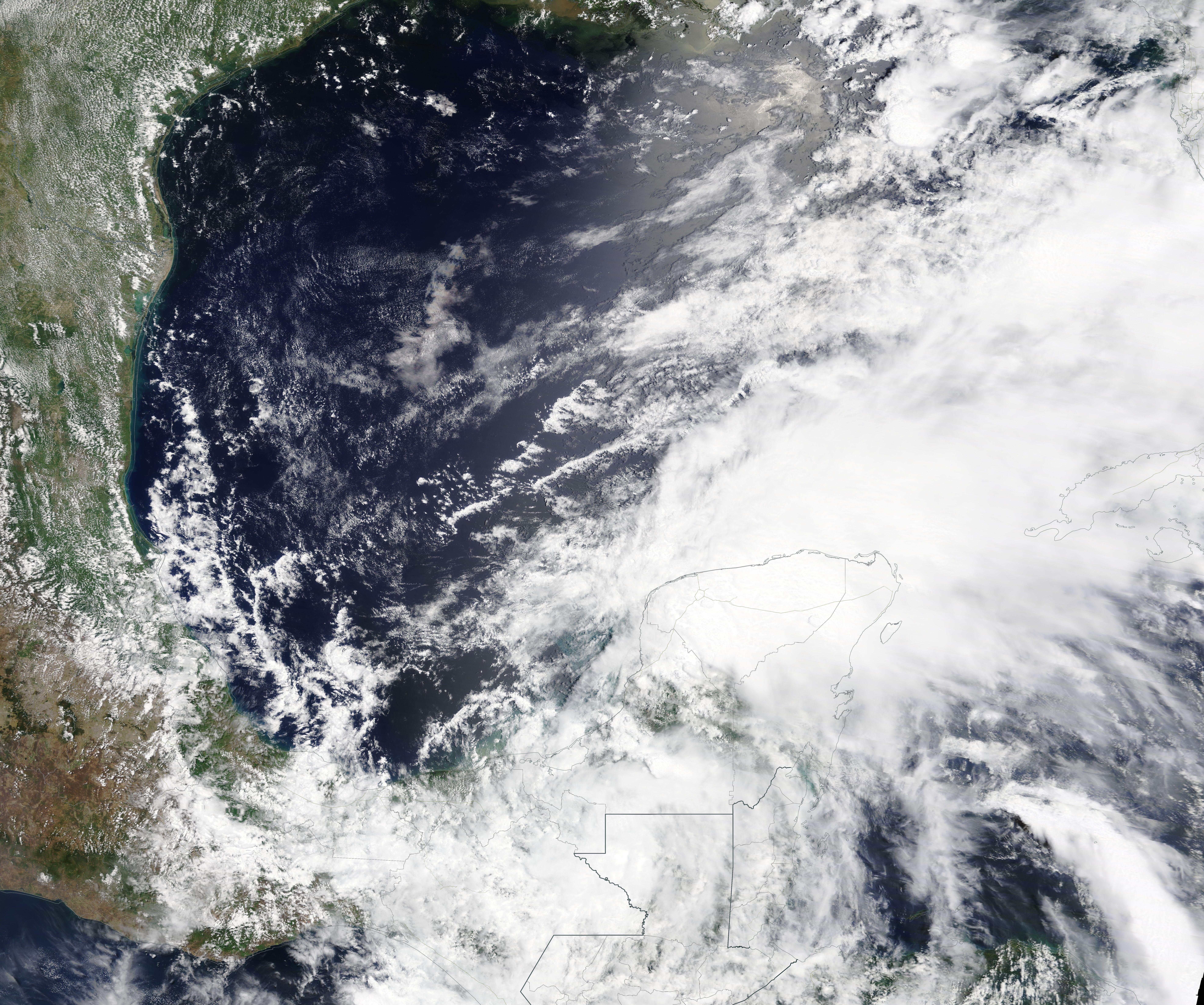
A low-pressure system churning in the southwestern Gulf has an 80% chance of becoming a tropical depression within seven days, the National Hurricane Center said Monday, Oct. 5.
Tropical depression could form by midweek
The NHC's 2 p.m. EDT advisory designated the disturbance as AL92, a trough of low pressure over the southwestern Gulf producing disorganized showers and thunderstorms. The agency gave the system a 60% chance of formation within 48 hours and an 80% chance within seven days. A tropical depression is expected to form by the middle of the week.
The system is expected to drift eastward over the next couple of days before turning northward. The NHC said it is too early to determine specific impacts along the northern Gulf Coast and urged residents there to closely monitor the system.
If the system strengthens into a tropical storm with winds of at least 39 mph, it would be named Isaias, the ninth named storm of the 2026 Atlantic hurricane season, the Naples Daily News reported.
The Weather Channel reported that the NHC tentatively scheduled a Hurricane Hunter reconnaissance flight for Wednesday afternoon. Forecast model tracks as of Monday ranged from the upper Texas coast to the Florida Panhandle, with a generally north-to-northeast path considered most likely.
Wind shear from a southward-sagging jet stream could limit how much the system strengthens over the northern Gulf, according to The Weather Channel.
Meanwhile, widespread rainfall across Central Florida could total 2 to 4 inches through Saturday morning, with isolated areas receiving more than 5 inches, according to WUSF. Much of Florida's rain this week is associated with a slow-moving front and local weather patterns rather than the developing Gulf system alone.
Sarasota stormwater work remains unfinished after 2024 floods
The wet forecast comes as Sarasota residents continue waiting for stormwater improvements promised after Tropical Storm Debby flooded neighborhoods in 2024. During that storm, water rose as high as doorknobs in the South Gate neighborhood. Rescuers using boats ferried families from the Laurel Meadows subdivision to safety.
A Suncoast Searchlight investigation published Oct. 2 found the county's stormwater department still has an 18% vacancy rate, with 10 field crew positions and the crew manager position unfilled since spring. The maintenance backlog, after briefly shrinking, has begun growing again.
County commissioners have committed more than $80 million to dredge clogged creeks, oxbows and bayous, but much of that money remains unspent. Contractors dredged about 1.7 miles of Phillippi Creek this summer, removing more than 60,000 tons of muck.
The permit for the creek's middle section, where some of the worst flooding occurred in 2024, remains under review. Stormwater Director Ben Quartermaine is targeting approval by the end of the year, but dredging there may not begin until 2027.
"We are probably going to be into the next hurricane season before something gets started," Kristy Molyneaux, a Phillippi Creek-area resident whose home flooded three times in 2024, told Suncoast Searchlight on Oct. 2.
Atlantic season remains unusually quiet
The 2026 Atlantic hurricane season has been unusually quiet despite eight named storms forming through Oct. 4. None has reached hurricane strength.
The season's accumulated cyclone energy, or ACE, stood at 10.8 through Oct. 4, 89% below the 1991-2020 normal for this point in the season, according to the National Hurricane Center.
Conditions and development probabilities for AL92 can change quickly. Residents can follow the latest forecasts and advisories on the National Hurricane Center website.



.jpg)