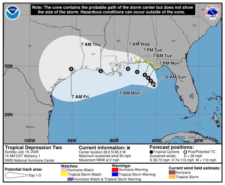
A tropical depression in the eastern Gulf of Mexico is expected to strengthen into Tropical Storm Bertha on Monday, July 20, bringing dangerous surf and possible flooding to Sarasota County's coast through the end of the week, even as the storm's center tracks well north of the area.
The National Hurricane Center's Advisory No. 5, issued at 10 a.m. CDT (11 a.m. EDT) Monday, placed Tropical Depression Two about 120 miles south of Panama City, Florida, with maximum sustained winds of 35 mph. The system was moving northwest at 3 mph.
The storm's projected track keeps its center aimed at the Florida Panhandle and northern Gulf Coast. No watches or warnings were in effect for the Sarasota area as of Monday morning.
What Sarasota residents should watch for
The NHC forecast 2 to 4 inches of rain across a broad swath of the Gulf Coast, from western Florida to the Middle Texas Coast, through Friday, July 25, with isolated totals reaching 8 inches. How much of that rain reaches Sarasota depends on the storm's track and outer band activity. No county-level forecast was available Monday.
Swells generated by the depression were already hitting portions of Florida's Gulf coast Monday. The NHC warned those swells are "likely to cause life-threatening surf and rip current conditions" and are expected to spread westward through the week.
The system's broad circulation was producing showers and thunderstorms across parts of the Florida peninsula Monday, the Tampa Bay Times reported.
Watches and warnings
A tropical storm watch was in effect Monday from the Ochlockonee River in the Florida Panhandle westward to the Jefferson/Plaquemines Parish line in Louisiana. A storm surge watch covered the Alabama/Florida border to the mouth of the Mississippi River, where surge could reach 2 to 4 feet.
Sarasota County was not included in any watch or warning area.
Strengthening expected, but uncertainty remains
NHC forecaster Jack Beven wrote that satellite imagery and radar data showed the depression "getting better organized" and that it was expected to reach tropical storm strength later Monday, with gradual strengthening continuing through Tuesday, July 21.
Gulf water temperatures in the mid-80s could fuel that intensification. However, the NHC noted that wind shear and dry air could limit how strong the storm gets and said confidence in the intensity forecast was lower than usual.
If the system reaches tropical storm strength, it will be named Bertha, the second named storm of the 2026 Atlantic hurricane season, after Tropical Storm Arthur in June.
No local emergency statement yet
Sarasota County Emergency Management had not issued a public advisory regarding the system as of Monday, July 20. The NHC was issuing advisories every three hours, with the next complete update scheduled for 4 p.m. CDT (5 p.m. EDT) Monday.
Residents can monitor the latest advisories at nhc.noaa.gov. The NHC also warned that an isolated tornado was possible over the Florida Big Bend region Monday.




.jpg)