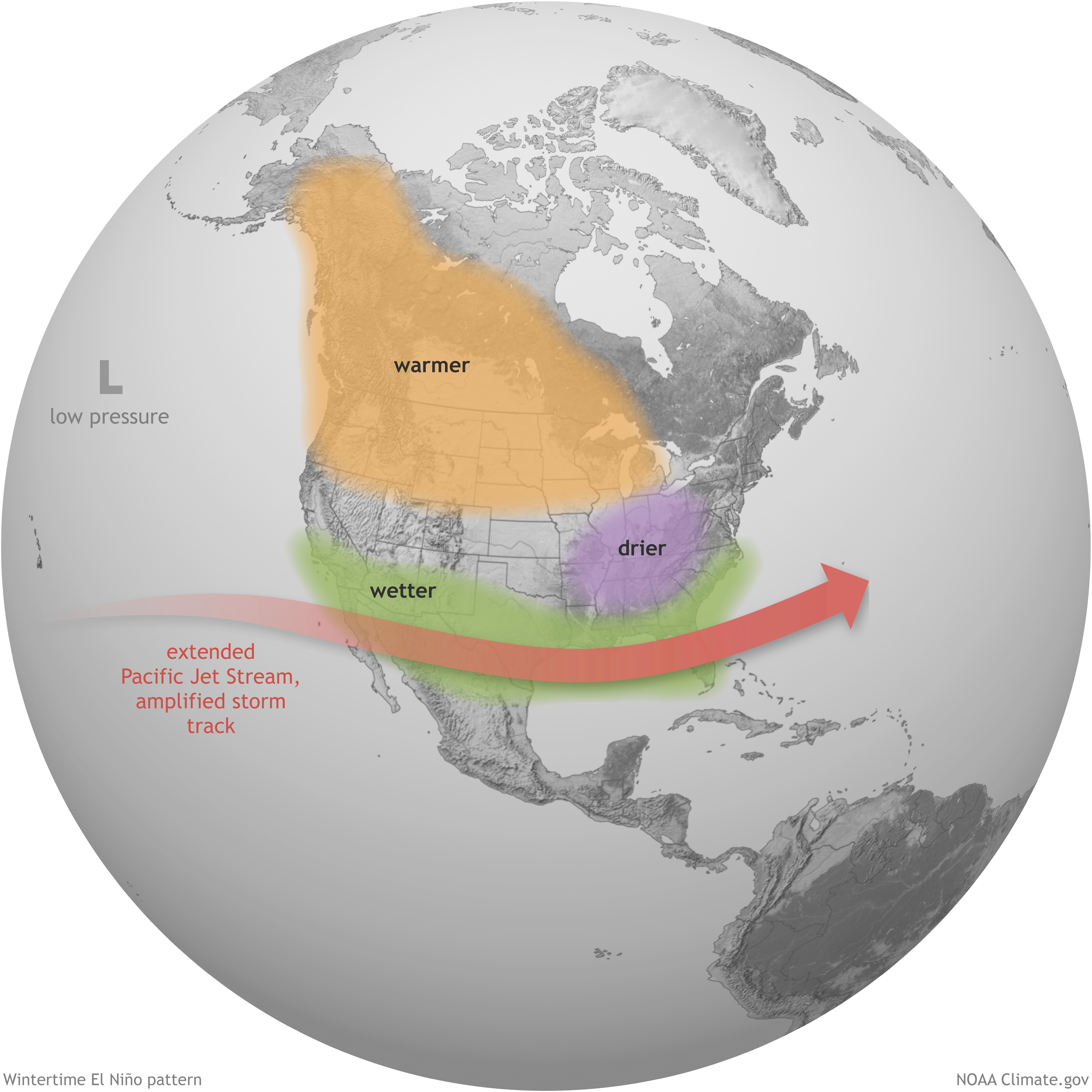
Sarasota County faces a wetter-than-normal fall and winter as the 2026 El Niño strengthens toward what forecasters call potential "super" status.
A Columbia University forecast projects the southeastern United States, including the Sarasota area, has a greater than 70% chance of above-normal rainfall from October through December. The National Oceanic and Atmospheric Administration's (NOAA) Climate Prediction Center now puts the odds of the El Niño reaching its highest strength level above 90%. There is a 69% chance it becomes the strongest El Niño since 1950, WFLA first reported.
The projection, from Columbia University's Center for Climate Systems Research, combines multiple climate models to map where the El Niño will push extra rain and where it will deepen drought. The pattern is expected to peak in late fall or early winter and persist into early 2027.
"El Niño is not the only thing that affects these seasonal forecasts, but it is one of the big drivers of it," said Jeffrey Shaman, senior vice dean and professor at the Columbia Climate School. "It gives a lot of certainty to the forecast."
The timing matters for Sarasota County.
The County Commission approved $32 million in stormwater projects on Wednesday, Aug. 26, to prevent future flooding at Bahia Vista, St. Armands and Celery Fields, all areas hit hard during the 2024 hurricane season, Suncoast Searchlight reported. The money flows through Resilient SRQ, the county's program for distributing federal recovery dollars. Sarasota County has received $210.5 million from the federal government for the 2024 storms and $201.5 million for Hurricane Ian in 2022.
One project is a $6.1 million plan to build a manmade wetland on a 4.7-acre parcel at 5542 Bahia Vista St. to absorb floodwater within a half-mile radius.
The St. Armands component could include upgraded pump stations, underground storage vaults and automated "smart gates" that open and close based on water levels.
During Hurricane Debby in 2024, some homes in the Pinecraft neighborhood sat under nearly 10 feet of water. A critical gate at Celery Fields was left open during that storm, worsening flooding for hundreds of nearby homes.
Sarasota County Stormwater Director Ben Quartermaine said at the Aug. 26 commission meeting that the county has spent significant resources to ensure drainage systems are working as efficiently as possible and that the county is better positioned to manage flooding than it was two years ago.
The El Niño's effects cut two ways for the region. AccuWeather senior meteorologist Adam Douty told Newsweek that increased wind shear across the Atlantic basin makes it harder for tropical systems to form and strengthen. NOAA raised the probability of a below-normal 2026 Atlantic hurricane season to 75% in its Aug. 6 update.
But the trade-off comes later. A stronger subtropical jet stream during El Niño winters brings a wetter pattern to Florida and can raise the risk of severe weather, Douty told Newsweek. He added that some of Florida's largest tornado outbreaks have occurred during El Niño years.
NOAA's seasonal outlook, released Aug. 20, confirmed that the Southeast is more likely to see above-average rain between September and November.
The next federal forecast update is expected as the El Niño approaches its projected late-fall peak.



.jpg)