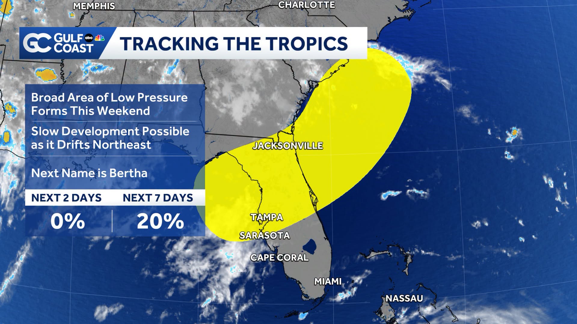
A low-pressure system expected to form over the northeastern Gulf of Mexico this weekend could bring heavy rain and gusty winds to the Sarasota area early next week, according to the National Hurricane Center's Thursday, July 16, forecast.
The National Hurricane Center gave the disturbance a 20% chance of tropical development over the next seven days. Forecasters said the system is likely to produce locally heavy rainfall across parts of Florida whether or not it develops into a named storm.
The National Weather Service's Tampa Bay office has identified moderate to extreme drought across west-central and southwest Florida, including Sarasota County. Any prolonged rainfall associated with the system could provide much-needed relief to the region.
Low-pressure system expected to form this weekend
The National Hurricane Center's Tropical Weather Outlook said an area of low pressure is expected to form over the northeastern Gulf by Saturday, July 18, or Sunday, July 19. Some gradual development is possible as the system drifts northeast toward the southeastern U.S. coast early next week.
Sea surface temperatures in the northeastern Gulf are running above average, reaching the upper 80s, according to Weather.com. While those warm waters could support thunderstorm development, forecasters said the system may not remain over open water long enough to strengthen significantly.
The most likely forecast track carries the disturbance northeast across northern Florida before either moving offshore along the Southeast coast or remaining inland. If the system reaches tropical storm strength, it would be named Bertha, becoming the Atlantic hurricane season's second named storm.
Drought conditions could ease with sustained rainfall
The National Weather Service continues to monitor moderate to extreme drought conditions across much of west-central and southwest Florida. Although heavy rainfall can cause localized flooding, widespread, steady rain would help replenish soil moisture and improve drought conditions across the Sarasota area.
Hurricane outlook remains below average
Colorado State University's updated July 2026 hurricane forecast calls for nine named storms this season, down from its earlier outlook and below the historical average of 14. Researchers attributed the reduced forecast primarily to a strengthening El Niño, which typically suppresses Atlantic hurricane activity.
However, Colorado State hurricane researcher Philip Klotzbach cautioned that Gulf systems forming close to the coastline may not be affected as strongly by El Niño.
"It's important to be prepared since it only takes that one storm near you to make it an active season," Klotzbach told the Houston Chronicle.
Rain chances increase into early next week
The National Weather Service's seven-day forecast for Sarasota calls for increasing rain chances through the weekend and into early next week as the Gulf disturbance develops.
Residents should continue monitoring forecasts and any advisories issued by the National Hurricane Center and the National Weather Service Tampa Bay office over the coming days.





.jpg)